Colorado Driving Tours Welcome to our historic driving tour...
Scenic Golden Loop Historic Parkway
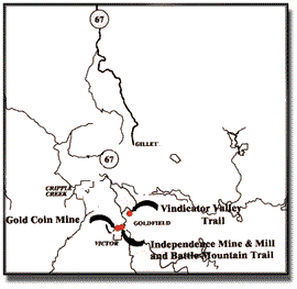
Cripple Creek and Victor, Colorado
We invite you to visit Victor & Cripple Creek and take a drive around golden loop.
The 1890s gold rush made this area one of the most famous mining districts in the world.
Thousands flocked to the area in search of golden wealth - leaving behind the mines and towns that still dot the landscape near Victor and Cripple Creek.
This driving tour is designed to help you better understand the history of the gold rush as well as the present day mining operations.
This tour, courtesy of the Southern Teller County Focus Group, is one of many ways to learn about the rich history in the mining district.You might also consider the following:
The Mollie Kathleen Gold Mine offers historic underground mine tours as well as tours of the modern surface mine and ghost walk tours are offered in Cripple Creek.
Walking tours of Victor are available at Victor businesses.
Walking tours of Cripple Creek are available at the Cripple Creek Welcome Center.
The Victor Lowell Thomas Museum, Cripple Creek District Museum and Old Homestead House offer exhibits and information on the gold rush as well.
The scenic American Eagles Overlook offers views of the Mining District, Continental Divide and modern day mining operations.
We are be building a series of historic interpretive trails in the Vindicator Valley and in and around Victor. Please visit our trails brochure on this website for more information.We hope you enjoy your visit and please, remember this is an active mining district - please stay on public roads and trails.
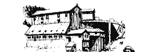
The historic photos in this tour are provided for reference to modern-day views.

WELCOME TO THE WORLDS GREATEST GOLD CAMP!
The Golden Loop Historic Parkway, which includes signs depicting roadways and historical structures, is a a mile-by-mile historical tour with information about mining past and present. Remnants of historic mines and ghost towns as well as modern surface mining operations are highlighted.
In addition, a series of trails and historic interpretation sites are located in and around Victor. The trails system provides access to Vindicator Valley, the historic location of the town of Independence, as well as several of the district's largest mines.
In addition, there are interpretative sites at the Independence Mine, which is on the National Register of Historic Places, and at the Gold Coin Mine, once owned by the city's founders, The Woods Brothers. A replication of the Cresson Ore Sorting House demonstrates ore sorting in the early part of the gold rush. In addition, the Battle Mountain Trail leads from this site providing views of Victor and the mines above the city.
Most sites along these roads are on private property, and for safety reasons please stay on the public roads/trails.Driving Tour
The CRIPPLE CREEK MINING DISTRICT has produced over 21 million ounces of gold since it was organized on April 5, 1891 and the old-timers insist that there is just as much gold left in the ground as has been taken out!We invite you to follow this brochure as you drive around the WORLDs GREATEST GOLD CAMP. If you stop to take pictures or to enjoy the view, please pull entirely off the roadway to let other vehicles pass. The brochure reads as though you started from Gillett and traveled in a clockwise direction around the district. If you choose to travel in a counter-clockwise direction or join the tour at one of the other access points, the mileage differences between points of interest still hold true. At each access point into the main loop or route, you should see a large sign with a map showing your location in reference to the tour brochure. Those traveling in a counter-clockwise direction, however, must convert the right to left and vice-versa. Mileages will vary slightly with different vehicles and rounding to the nearest tenth of a mile.
[0.0 mi.] #1) The tour starts on Teller County Road #81 just south of the intersection with State Highway #67. A large sign is mounted here that shows a map of the district and the route of the tour. Behind you, to the north, the large flat area hosted the GILLETT TOWNSITE. GILLETT was named for W.K. GILLETT, auditor for the MIDLAND TERMINAL RAILROAD, and started as a railroad town. It served as the terminus of the MIDLAND TERMINAL RAILROAD until it continued on to VICTOR and CRIPPLE CREEK. There were boarding houses, bars, a race track, a gambling casino, and ST. DIMAS OF THE MOUNTAINS chapel of which only a few stone pillars remain off to the west of State Highway 67. The chapel was built by Father Volpe in 1893-94; later the furnishings of the chapel were moved to ST. PETERS CATHOLIC CHURCH in Cripple Creek. GILLETT also hosted the only bull-fight on record at that time in the United States!
The boulders that you see to your left are a result of a cloudburst in 1965 which caused the failure of the main dam at the reservoir for the CITY of CRIPPLE CREEK. The resulting torrent of water in turn destroyed the penstock for the SKAGUAY HYDRO-ELECTRIC PLANT which was never rebuilt and the plant, itself, never resumed operation.[2.9 mi.] #2) As soon as you pass over the cattle guard, the access from the GOLD CAMP ROAD (Teller County Rd. #8) is off to your left. If you join the tour at this point, look at the route map sign to check your location. The road which connects with Colorado Springs was, originally, the roadbed of the COLORADO SPRINGS & CRIPPLE CREEK RAILROAD. After the sale of the line at public auction in 1924, the roadbed became the CORLEY MOUNTAIN HIGHWAY (a toll road). Later, the government purchased the right-of-way and the roadbed became a U.S. Forest Service road for public use. It is unpaved, narrow in places, has blind curves and is rough in spots but provides a scenic drive into or from COLORADO SPRINGS.
[4.1 mi.] #3) Continue on to the next intersection. On your way, you will see vestiges of the railroad roadbeds for the MIDLAND TERMINAL (upper) and the COLORADO SPRINGS & CRIPPLE CREEK RAILROAD (lower). Far up the valley, on your right, is the site of CAMERON. Originally, this town on the MIDLAND TERMINAL RAILROAD was called GASSY and then GRASSEY.
[5.0 mi.] #4) Continuing on up One Mile Hill, you will come to another intersection at the crest (VICTOR PASS). The second right takes you to the Vindicator Mine Site.
Directly behind you stands PIKES PEAK at 14,110 feet above sea level.
[5.1 mi.] #5) As you start down the hill on the paved road, immediately to your left were multiple sidings for the MIDLAND TERMINAL RAILROAD. Just below this stood the TAYLOR & BRUNTON SAMPLER and below this are the remnants of the railroad marshalling yard of the COLORADO SPRINGS & CRIPPLE CREEK RAILROAD or SHORT LINE.
[5.3 mi.] #6) A pulloff to the right takes you to the Vindicator Valley Trail. This 2-mile trail winds through the 1890s mines of the valley.
The THERESA HEADFRAME off to your right as you face the sign was intermittently active from 1895 until the 1950s.[5.6 mi.] #7) The cribbing on your left marks the location of the GOLD KNOB MINE. Off to your right, at ground level, remnants of the foundations of the LA BELLA COAL-FIRED STEAM PLANT may be seen at the toe of the reclaimed slope of the THERESA MINE dump. This power plant also supplied compressed air to many mines to run rock-drills, etc. (for a fee, of course). High above on the right (BATTLE MOUNTAIN), a small concrete foundation marks the site of the EAGLE SAMPLER.

Just beyond the cribbing, the town of GOLDFIELD lies off to your left. It was platted in 1894 by the PORTLAND GOLD MINING COMPANY for employee housing and still boasts many full-time inhabitants. The historic CITY HALL/FIRE STATION, built in 1896, is currently undergoing renovation by a group of dedicated GOLDFIELD residents.[6.5 mi.] #8) Continue on down the paved road until you are just short of the intersection. Pull off to your left to the parking places at the VICTOR/BATTLE MOUNTAIN INTERPRETATIVE SITE. This exhibit is one of many along the GOLD BELT SCENIC BYWAY.
The road to the left, with your back to GOLDFIELD, leads to the PHANTOM CANYON, following the railroad bed of the FLORENCE & CRIPPLE CREEK RAILROAD to U.S. HIGHWAY 50 which runs along the Arkansas River. The turnoff to the SKAGUAY DAM, the water storage reservoir for the SKAGUAY HYDRO-ELECTRIC PLANT is about 1 mile along this road. The PHANTOM CANYON ROAD is not suitable for RVs over 25 feet in length! The unpaved road has many tight, blind curves, narrow tunnels, narrow bridges and steep grades; drive safely and enjoy the scenery.
Just in front of you as you stand on the deck of the interpretative site, are the concrete foundations of the processing mill for WINFIELD SCOTT STRATTONS INDEPENDENCE MINE.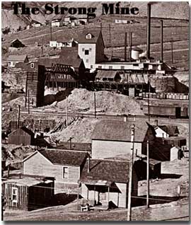
[6.7 mi.] #9) As you continue the tour on the road to your right, you will see the grey, timbered headframe of the STRONG MINE. The mine was the site of both an explosion during the labor wars and a battle between the FLORENCE & CRIPPLE CREEK and the MIDLAND TERMINAL RAILROAD over the right to haul ore from the mine. From 1891 until 1957, the mine produced over $13 million in gold. The property is once again undergoing rehabilitation and exploratory work.[6.8 mi.] #10) The CRESSON HEADFRAME stands to your left in the GOLD BOWL. This headframe was originally erected over the GOLDEN CYCLE MINE in GOLDFIELD in 1893. It was moved to the CRESSON MINE west of Victor in1923. At the CRESSON MINE, it replaced a small wooden headframe allowing the mine to sink deeper into the caldera in search of gold. The CRIPPLE CREEK & VICTOR GOLD MINING COMPANY moved the structure to this site in 1994 to commemorate VICTORs great mining heritage.
The CRESSON, known locally as the DUKE, produced over $49 million in gold up through 1962, all from gold that sold under government mandates at $20.67 per ounce until 1934 when it was raised to $35 per ounce. Today, the CRESSON lives on with the surface mine extracting gold from rock too low in values for the old timers to mine. It was on the 12th level of the CRESSON in 1914 that miners broke into a vug or chamber likened to a large geode that contained over 60,000 ounces of gold. This was sacked up and transported to the smelter in Denver under armed guard. Imagine finding over $18 million worth of gold at todays prices in a room about the size of a standard living room but about four times as high![6.9 mi.] #11) Continue on for one block past the CRESSON HEADFRAME and turn left. The brick building on your right as you start the turn is now a private residence. This structure once housed the offices of the COLORADO TRADING & TRANSFER COMPANY, at that time the main supplier of coal and other commodities for the District. At the next intersection, turn right.
At this point we recommend a stop for a walking tour of Victor. Tour maps are available at local businesses.
Proceeding along VICTOR AVENUE brings you to the historic CITY HALL, on your right and currently under refurbishment. High above you on the right, above CITY HALL, stands the headframe of the AJAX MINE. The steel headframe, installed in the 1950s to replace a wooden headframe, came from the Pikeview Coal Mine in Colorado Springs. The shaft itself is 3350 feet deep and was last worked in 1985. The Ajax Mine has produced over 1,300,000 ounces of gold. Lower down and directly behind CITY HALL are the remnant brick and stone foundations of the GOLD COIN MINE. The mine was located when the WOODS BROTHERS dug a foundation for a hotel and found a gold vein. They followed this a short way up the hill and sunk a shaft which was eventually over 1200 feet deep. The surface plant was destroyed in the 1899 fire and rebuilt in brick, including stained glass windows. As the city had grown up around the mine, there was no room to dump the development rock or to mill the gold ore. The WOODS BROTHERS drove a 3600 foot tunnel from the first level in the shaft through SQUAW MOUNTAIN into AREQUA GULCH to the west. Here they erected the ECONOMIC CHLORINATION MILL to process their gold ore and the steep gulch provided room to dump the development rock too low-grade to process. The Gold Coin site houses the districts only remaining flat-rope hoist.VICTOR hosted many other mines within the city and immediate area earning it the sobriquet - VICTOR, CITY of MINES. These mines supplied most of the 21 million ounces of gold that have come from the District in the past 100 years.
[7.4 mi.] #12) VICTOR CEMETERY: Soon after you have passed through the rock-cut as you leave VICTOR, you can see below the road to your left in the mid-distance, the graveyard with its arched entrance. It can be accessed via South Seventh Street in VICTOR. Generations of VICTOR families lie buried here in addition to the victims of the influenza epidemics during World War One.
[8.1 mi.] #13) AREQUA or ECLIPSE GULCH: Just before Arequa Gulch you will see a parking area on the left with a mining exhibit and trailhead for Little Grouse Mountain trail. The hike up the mountain offers great views of the surrounding mountains.
On your right, is the valley fill facility of the CRESSON surface mine. After drilling and blasting, gold bearing rock is hauled by up to 310-ton capacity trucks to the crushing and screening plant; it is crushed and transported to the leach pad at the right. The leach pad is engineered to recover gold from very low-grade gold bearing rock formerly considered as non-economic. A drip system on the leach pad supplies a very dilute solution of cyanide to the heap and as the solution migrates down through the heap, the gold is dissolved. This gold bearing solution collects in the bottom of the triple-lined section of the pad which can be likened to a big bathtub. From here it is pumped to the Hunter ADR Plant off to the right corner of the pad. At the ADR plant, the gold bearing solution is processed and heated to about 2000 degrees Fahrenheit. The melted gold is then poured into cone-shaped molds, cooled, weighed and shipped out to a refinery for further processing.
From this parking area proceed over the highest bridge on the Colorado State Highway System. The 250-foot bridge crosses Arequa Gulch and was constructed by the Cripple Creek & Victor Gold Mining Company.
[9.2 mi.] #14) As you continue through the small road-cut, you are actually crossing the BEACON HILL PHONOLITE PLUG. The EL PASO MINE HEADFRAME can be seen to your left on the left side of the valley and along the western perimeter of the plug. The HIAWATHA HEADFRAME sits further to the south. The EL PASO HEADFRAME is slightly warped due to a fire that destroyed the ore-sorting house many years ago. Several mines worked the ore bodies on the perimeter of the plug but the EL PASO was the largest of these mines, producing intermittently up through 1956. The sloping structure on the right side of the valley (GOLD RUN) is a small mill utilized for the MARY NEVIN MINE located just this side of the mill. The RAALER, LONACONNING, HENRY ADNEY, OLD GOLD and CK&N were among the many mines working the geological structures under the valley floor. Just below the highway on the left side are some brick structures of the NICHOLs MINE, part of the EL PASO, which was operated as a tourist mine.As you continue on State Highway 67, you will round the curves into SQUAW or ANACONDA GULCH.
[9.9 mi.] #15) The timber wall or cribbing that you pass beside on your right, supported the dump rock of the MARY McKINNEY MINE. This cribbing was originally placed here to permit the passage of the FLORENCE & CRIPPLE CREEK RAILROAD on what is now the highway. The CRIPPLE CREEK & VICTOR GOLD MINING COMPANY regularly monitors this cribbing for stability.
[10.0 mi.] #16) The ANACONDA TUNNEL portal lies just above you if you enter the pulloff at the middle of the tight hairpin curve. The portal is just east of the old Blacksmith Shop (with the cupola). This area is also the terminus of the CRIPPLE CREEK & VICTOR NARROW GAUGE RAILROAD which starts from CRIPPLE CREEK next to the CRIPPLE CREEK DISTRICT MUSEUM and gives visitors the experience of riding a steam-powered train along part of the old MIDLAND TERMINAL RAILROAD route. The unpaved road to your left leads to the SHELF ROAD.
[10.2 mi.] #17) GRATED ADIT: The grate to your right is one of many installed by the OFFICE OF ACTIVE & INACTIVE MINES, COLORADO DIVISION of MINERALS & GEOLOGY to prevent the unwary from wandering in and suffering injury in old, unmaintained workings. Many of these old workings have become a habitat for bats and special closure grates have been installed on these openings to permit bat access and egress.
The pull-off just past the grated adit on your right gives you a good view of GUYOT HILL across the valley. The ore-house of the CHICKEN HAWK or KATINKA MINE sits almost straight across, on the skyline. The HOBO TUNNEL portal is directly below this. Looking to your left, the tall, spindly headframe is the GOLDEN WEDGE and below that the JULIA E. HEADFRAME of the OPHIR MINE. The remnants of the MORNING GLORY MINE can be seen even further to the left on the east side of the valley.
Continue to Cripple Creek; turn right on Bennett Avenue and drive to the sharp left turn at the east end of town and park in the parking area near the Welcome Center.[12.5 mi.] #17) CRIPPLE CREEK DISTRICT MUSEUM: The parking lot for the museum at the east end of Bennett Avenue provides an opportunity to leave your car and visit the museum. Here you will gain a wonderful insight into the history of CRIPPLE
CREEK and some of the Districts mining and cultural heritage. To the right of the museum, as you enter, is the GOLD SOVEREIGN HEADFRAME donated by the CRIPPLE CREEK & VICTOR GOLD MINING COMPANY and moved to this location from the CRESSON VALLEY.
A walking tour of the City starts at the museum entrance and allows the visitor to learn about the various historic buildings along Bennett Avenue. Each designated building is marked with a plaque to identify it and some of its history. The walking tour ends in the City Park where a statue honoring BOB WOMACK stands. BOB was a ranch hand who spent all of his free time prospecting and eventually became the discoverer of gold in the District. Just across Bennett Avenue from the park is the TELLER COUNTY COURTHOUSE built following the two great fires that leveled CRIPPLE CREEK in 1896 and the Butte Opera House, an 1890s theater refurbished by the City of Cripple Creek.To the left of the museum is the CRIPPLE CREEK & VICTOR NARROW GAUGE RAILROAD STATION. The steam locomotives provide a chance to experience a mode of transportation all but forgotten today. The trip to ANACONDA provides the opportunity to see part of the district not visible from the road.
[13.3 mi.] #19) High above the road at the first switchback stand the remnants of the portal area of the SANGRE DE CHRISTO TUNNEL.

[14.09 MI.] #20) MOLLIE KATHLEEN GOLD MINE: The MOLLIE was located in 1891 by MOLLIE KATHLEEN GORTNER. The mine tour provides an opportunity to travel by mine cage 1000 feet underground! There the visitor will be shown how gold was mined here in the District for many, many years.Just below the MOLLIE is the headframe of the GOLD KING MINE, the site of BOB WOMACKs initial gold discovery and an early producer in the District. Unfortunately, WOMACK sold out for a pittance. The gulch or valley to your right as you ascend the grade up to the MOLLIE is POVERTY GULCH.
[14.3 mi.] #21) GOLD BELT SCENIC BYWAY PULLOFF: This kiosk, erected by the BUREAU OF LAND MANAGEMENT, provides information on the early, historic routes into the District.
CARBONATE HILL lies to your immediate right. Originally the site of small underground operations, it was reopened in the 1980s as a small surface mine. The rock from the mine supplied a small reclaimed heap leach pad down in the valley. MINERAL HILL lies just to the west of CARBONATE HILL and was the site of early attempts to mine the small amount of placer or free gold that was found there.
[15.3 mi.] #22) TENDERFOOT HILL: Off to your right, as you round the curve, was the site of a 1970s ski run but lack of snow even at an elevation of over 10,100 feet doomed the project from the start.
[15.6 mi.] #23) RHYOLITE MOUNTAIN stands off to your left. During the rush to the District, prospectors searched for miles around the center of the District and some sporadic mining activity was conducted here.
[17.5 mi.] #24) GILLETT and the end of the large circle tour of the Mining District.
SUPPLEMENTAL or ADDITIONAL TOUR ROUTES
SUPPLEMENTAL TOUR No. 1
[0.0 mi.] #34) The route begins at the intersection of STATE HIGHWAY #67 and the SHELF ROAD just south of CRIPPLE CREEK (#25 on the main tour description). This is a narrow, unpaved road so you must be on the lookout for oncoming traffic.
[0.7 mi.] #35) The timbered wall or cribbing on your left confines the development rock dump from the OPHELIA or MOFFATT TUNNEL.[1.2 mi.] #36) ROAD FORK Turn to your left to continue the tour up SQUAW or ANACONDA GULCH. The road straight ahead would take you down the SHELF ROAD proper (named for the portion of this narrow winding road that goes along a narrow ledge of sedimentary rock south of the granite surrounding the caldera). This road is NOT passable by RV units.
As you turn to the left, the ROSEBUD STAMP MILLs beautiful rock-wall foundation is to your right. Although stamp mills were brought into the district right after gold was discovered, they were very unsuccessful. These mills used mercury to amalgamate or collect the gold and were very successful the world over EXCEPT in this district. What free gold was present here was coated with a film of iron telluride that resisted amalgamation. Gold recovery was very poor as a result and alternative methods were introduced. This immediate area was the location of the townsite of MOUND CITY.
[1.4 mi.] #37) BRODIE MILL: This mill, under the direction of Philip Argall, pioneered the efficient use of cyanide for gold recovery in the district. Although chlorination was widely used in the district for many years after the failure of stamp mills, the cyanide recovery system was finally judged to be the most efficient for recovery from CRIPPLE CREEK gold ores. By 1911, all chlorination mills were gone. Argall went on to become one of the eminent metallurgists of his time.
[2.0 mi.] #38) ANACONDA TOWNSITE: The town occupied both sides of the road as you approach the intersection with STATE HIGHWAY #67. The MARY McKINNEY mine cribbing to your right is back on the main tour route. Straight ahead, the little buildings that you see are located at the portal of the ANACONDA TUNNEL. Today, they serve as the terminus of the CRIPPLE CREEK & VICTOR NARROW GAUGE RAILROAD from CRIPPLE CREEK. The small town of BARRY was located between MOUND CITY and ANACONDA and was later absorbed into ANACONDA.

[2.1 mi.] #39) Turn to the left at the intersection and travel to CRIPPLE CREEK or turn to the right and continue to VICTOR and two more supplemental tours.

THANK YOU for taking the tour through our great mining district.
We hope that it has whetted your interest in learning more about THE WORLDS GREATEST GOLD CAMP. For additional reading about the CRIPPLE CREEK MINING DISTRICT, the following, while not a complete list, should be a helpful beginning:
CITIES of GOLD by Brian Levine
CRIPPLE CREEK, A QUICK HISTORY by Leland Feitz
CRIPPLE CREEK DISTRICT by Robert Guilford Taylor
MINES OF THE CRIPPLE CREEK DISTRICT by Bill Munn
MONEY MOUNTAIN by Marshall Sprague
VICTOR, A QUICK HISTORY by Leland FeitzWe appreciate the contributions of the following sponsors of the tour signs and brochures:
Colorado Division of Minerals and Geology
Cripple Creek Ace Hardware
Cripple Creek Chamber of Commerce
Cripple Creek Parks & Recreation
Cripple Creek & Victor Gold Mining Company
The Mollie Kathleen Gold Mine
Monarch Gallery
Victor Historical Preservation Commission
Victor Chamber of Commerce
Ed & Cherry Hunter
Steve & Bonnie Mackin
Marvin Bielz
Dave & Judy Crawford
Karen Leaf
Mickey Nothaus
T.J. & Lee Walker
Ruth ZirkleThe Golden Loop Historic Parkway Driving Tour is a project of the
Southern Teller County Focus Group.
Driving Tour Signs designed by Victor Artist Cherry Hunter.
Brochure was written by Victor Historian Ed Hunter.
Cover design by Victor Artist Ruth Zirkle.